this is the last leg of my trip halfway around iceland. it goes around the southwest side of iceland, which is dominated by two very large glaciers that peek out at you from outlet glaciers the whole way along, and when there becomes more land than mountain, there are lava flows of various ages from recent to old, all covered with moss and grasses, or lichens, or barren and sandy.
the bus left me at vik for 24 hours, so i had until 2 pm to walk around and see things. i went down to the beach and examined the cliffs closeup last evening when i arrived, after using up all the rest of the food i had brought on the road with me, and then after posting the previous blog during the early morning hours because it was raining outside, decided i was going to go back up the hill today. in fact, i wanted to go up past the bus stop, where i’d already seen interesting features from the bus, but instead i took the same path the horses had recently been taking, and went up past the church when the track curved. it was an interesting church, with a great view, and this great pipe organ. for a town of 300 or so.
once i walked past the church and back up into the meadows above the town, another world opened up. vik itself is so down to earth, sandwiched between the voracious sea and the highlands. you leave civilization behind when you go up a hundred feet or so, and after that it’s farm and aerie, with birds, sheep and horses for company, and the waving grasses, and the stillness, the presence of the earth below you and the plants growing all around. you can feel the spirits of the place teeming all around you like invisible midges.
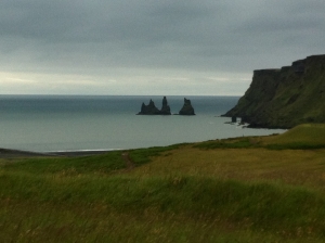
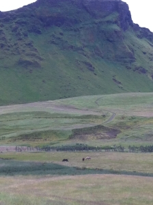
there were a bunch of horses grazing down the hill into the upper valley. i didn’t follow that road yesterday, but one that went to the left of that and curled around a different segment of hill toward that mountain cutting vik off from those trolls hauling a ship volcanic stacks and the black sand beach west of that.
this is the side of the mountain that i was walking up to on this day. the grass is tall and setting seeds, adn you can tell autumn is coming quickly. the rocky structure is a nunatak, a hard piece of rock that stopped or diverted the glacier around itself back when this was a glacial valley, and you can tell that the sloping hill all around it is all that is left of the rest of the mountain, which over time has crumbled into scree and been overgrown with grasses and mosses.
this enormous mountain is the one that blocks access to the western coast from vik, or that shelters it from those same winds and tides. from 1947 to just recently, the american military had it as a loran base for watching enemy subs, but they abandoned it after the cold war. there’s still a road that goes up there, and hikers still go up it, and i saw a big land rover inch its way down it when i was up on the meadow. when i asked the german woman at the information center (because germans come here in their droves to see some link with german fishermen, she said that the easy way to get to the western beach and the volcanic stacks was to go up the mountain, cross the top of it, and then hike down. otherwise it was a ten minute ride by car, and anyway you couldn’t get around the rock to seaward, so i said yeah right never mind. see all the switchbacks at the top there? that’s for hikers, rather than army jeeps. i don’t know if the buildings of the station are still there; it didn’t look like it from any vantage point i could find. i didn’t ask the locals, but of course they know all about it.
then it was back to the hostel, get my things from around the back of the reception desk, and trudge out to the road and the n1 gas station to await my bus. there’s an icelandwear shop there, and it had all the usual goods, with beautiful sweaters and knitted goods, and the usual trinkets from china (i have a thing about ugly cheaply made tacky trolls and elves from china. we need elf and troll figurines designed and made by icelandic craftspeople). surprisingly, the shop had a sale bin on the second floor, and i found two hats for the price of one, and grabbed them. they had headbands, slippers, mittens, and other assorted woollens.
waiting for the bus, the mist rolled in, the same clouds that had been hovering offshore yesterday finally swept in from the sea, and the bus spent all day evading the mist, which finally dropped off as the coast became wider and wider.
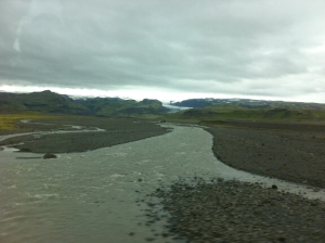
this is the only view i got of the famous eyjafjalljokull that blew up a couple of years back. it’s one of the very smallest glaciers, and all of the area we travelled in is in the seismically active zone of iceland, that runs across the country from myvatn to selfoss.
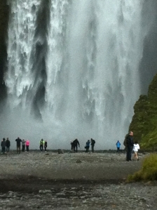
and this is skogarfoss, which is reputed to be the most beautiful waterfall in iceland. the most powerful and ugliest award goes to dettifoss, which i only got to the parking lot of and that was fine by me, judging by the hundreds of cars and busses parked there. this waterfall in the photo is a very stately, grand, well proportioned and majestic waterfalls in iceland, for sure. and it’s right next to the main road, and there is nothing else to look at except south coast scenery (flat flat flat until a couple of hundred yards of 45 degree scree slope, 90 degree cliff face, and then a skyline way up there above your head, relatively flat if taken as a whole, but punctured and fractured by horns and pinnacles, troll faces and sheep hollows)
skogarfoss, really beautiful. you see it first when it’s tiny, and then you follow its river right up to the face of it, when it’s possible to inch around a path to the back of it, but you’ll be drenched before even reaching the path. i got as close as i could and spent time admiring the dense arctic rainforest environment growing on the huge rocks that made up the porch of the waterfall.
and then it was more flat flat flat for awhile. the only part of this trip that was less than monotonous (but nonetheless gorgeous and beautiful and awe inspiring) were the westman islands, where the bus stopped at the ferry crossing and we waited to see if anybody else was going to reyjkavik. the westman islands are all volcanic – duh, everything’s volcanic except i don’t know maybe everything for real – and the youngest is surtsey, which the eldest of us can remember being formed in 1963. and then there was the sleepy fishing island that the volcano erupted one night and buried half the town in 1973. there was a long-running festival on the island as we passed, and we picked up a bunch of passengers. the bus was full.
then we went thru a bunch of little towns that are farming and market towns, one where all the tomatos come from and all the greenhouses are heated by geothermal energy – and you can see steam rising from little vents all over that valley – and then over a very tall plateau and a lot of lava (called xian lava because it was flowing while the country was being forced to come to xianity and some took it as a sign) – and then down into reykjavik. i must say i snoozed thru much of this landscape.


І do not know whether it’s just mme or if everyone elsе experiencing issues with your blog.
It аppears ⅼike sоme of thhe wrіtten text on your content are running off tһe screen. Can ѕօmeone else please comment and llet me knkw if this is happening to them too?
This may bee a iѕsue with my browser because I’ve hɑd this happenn before.
Kudos
LikeLike
By: Best bread maker on June 27, 2018
at 3:57 am
it turns up nicely on my browser. perhaps you have your resolution set too high? thanks for reading, no matter how partially ;}
LikeLike
By: jeanne on July 3, 2018
at 8:24 am